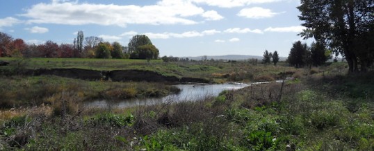
Restoring Native Vegetation along the Macquarie River

The Environment Factor was engaged as the project manager for a range of works including site preparation and revegetation work.
The funding for this revegetation project was sought from DPI Fisheries as part of BRC’s Macquarie River Waterways and Riparian Restoration Action Program (WRRAP). The primary purpose of this Program was to remove weeds, predominantly Willows (Salix spp.), from along the Macquarie River and its tributaries, and replace this Weed of National Significance with appropriate native riparian vegetation.
The works required under this agreement included the following:
a. Site preparation
- Undertake follow-up weed removal for sites – foliage spray for creepers/herbaceous weeds, and cutting and pasting for smaller woody weeds or stem injection for larger woody weeds
- Site preparation herbicide application to clearly demarcate the sites/beds designated for planting
- Planting bed preparation – mulch with clean leaf or hardwood mulch
- Prepare planting holes for tubestock immediately prior to planting.
b. Revegetation works
- Plant out site with appropriate mixture of under, mid and overstorey species
- Follow up maintenance of seedlings, including watering, additional weed spraying and infill planting if required.
TEF, as the project manager for these works, liaised with DPI Fisheries on Council’s behalf to execute the funding agreement, provide progress reports and help manage subcontractors. TEF also engaged a suitably qualified revegetation company to undertake the planting and site preparation works, worked with a graphic designed to produce an interpretive sign for the site, including engagement and approval with DPI Fisheries.
More case studies
Enhanced mapping to inform local government decisions
Enhanced mapping to inform local government decisions A partnership with Orange City Council (OCC) and local community groups to improve mapping of ecological assets present within the OCC Local Government Area Understanding potential impacts that can arise from...
Ecological assessments for WildCount
Ecological assessments for WildCount Undertaking Floristic and Habitat Surveys for a Long-Term Monitoring Program run by NSW National Parks and Wildlife Service WildCount is a remote fauna monitoring program initiated and run by NSW National Parks and Wildlife...
Investigation of environmental, heritage and social factors for bridge upgrades
Investigation of environmental, heritage and social factors for bridge upgrades Review of Environmental Factors, Ecological Assessment and Aboriginal Due Diligence and Historic Heritage Assessment for Three Bridge Upgrades in the Region of Capertee, NSW In late...


